

 With two weeks to go until the race, Molly, Justin, Scott, & Scott set out to organize a weekend soiree into the Blue Ridge Mountains near Roanoke, Virginia....
After flying from Minneapolis to Washington-Dulles on Friday morning, driving 4-hours into central Virginia, putting our bikes together, eating dinner, attending the pre-race briefing, driving back to our hotel, plotting UTM coordinates, deciding routes, and finalizing gear, we finally hit the beds at 12:15am. Just in time for our 3:15am wake up call to drive back to the host venue, Wilderness Adventure at Eagle Landing (WAEL), for the 4:30am start.
The race began with a 2-mile "prologue" trail run around WAEL. We returned to our bikes after about 20 minutes, and tried to make a quick TA into our biking gear. The first bike leg started off with a 1 hour, 30 minute (2300') climb up
CPs on the mostly-trail trek from Hoop Hole parking area were located in a swimming hole on the Hipe Branch, Rich Knob (3704'),


We ran back to the Hoop Hole parking area via road, stopping at a convenience store along the way to fill up on water and buying the last three Gatorades they had.
Returning to the TA, we passed a comprehensive gear check and transitioned back to bikes for a speedy pavement ride from Hoop Hole parking area to Eagle Rock public boat ramp, about 8.5 miles east.
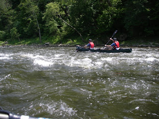
We then loaded our bikes into our canoes and strapped them down for an 18-mile paddle from Eagle Rock to Horseshoe Bend public boat access and on to Springwood public boat access.

Erl and Scooter rocked Aquabound kayak paddles (that we carried with us the entire race) while Mo and Biz used the provided canoe paddles. Class 1 & 2 rapids made the trip exciting as we paddled during the hottest part of the day.
After getting off the water, we felt baked - wish we would have remembered to put on sunscreen at 4:30am! We hopped onto our bikes for a 24.5-mile ride back west on a mix of paved/gravel/two-track from Springwood to the intersection of FR5020 & FR184. The climb up to CP 12 and over the pass near the SW part of
After finding the first two score-o CPs in daylight, night began to fall on the Patterson Creek area. A lightning storm passed overhead just as we were coming down off the top near CP K going to CPs E and A, which quickened our pace greatly. Biz was pretty sure that he has never navigated at night in such a downpour - visibility was seriously lacking at about 20 meters. Vegetation was also thick below thigh level along most "trails," which slowed the pace. Climbs to ridge tops at CPs K (2285') and G (2250') were "highlights." Erl and Biz also picked up 12 littered glass bottles at CP B and carried them through the rest of the race for a 12-minute time credit. Our team battled some stomach issues throughout the night, but was able to keep a steady pace late in the game. Here's us not looking too pretty...
 We returned to the Patterson Creek TA about 8.5 hours later to find ourselves in basically the same position as when we left - 2nd place overall with a 40-minute gap behind solo racer Triangle AR.
We biked the final leg from Patterson Creek area back to WAEL pavilion, crossing a knee deep stream along the way (maybe that's why the directions to WAEL don't tell you to go the short way?).
We finished the race in 24 hours, 21 minutes, garnering 1st in 4-person coed (and 2nd overall). Our 12 bottles brought our official time down to 24:09, with all mandatory and optional CPs. Triangle AR finished about an hour ahead of us and was the only other "team" to obtain all CPs. This was a tough race that definitely pushed us to the limits. A great east coast event put on by Odyssey AR with lots of awesome views from the Blue Ridge Mountains of
 We passed under a few bridges over head, then through a small tunnel for a road. Then we came to a huge tunnel that we couldn't see the other side of - it was completely pitch black. Maybe this is why the race directors had "recommended" that we bring a headlamp!
 Holding tight to our make-shift "trekking" poles that we found on the way to the river, we precariously traversed the rocky, unknown ground, step by step, in total darkness. Sure Biz could have gotten that headlamp out of his pack before we got to the darkest part, but what fun would that have been? After a bend in the tunnel, we could finally see a small bit of light at the other end. We picked up our pace into the sunshine, and finished the creek trek at CP15 - the bottom of Minneopa Falls.
 A short jaunt to the top and we transitioned to biking. We pushed the pace on the bikes a bit, as Andrew Kroese and Tom Puzak of Free Candy (24Seven) closed the gap from the O-section on the upstream trek. On the bike leg, we took a few different route choices, they had a flat tire (or two), and we made it to the paddle TA with a 5 minute lead.


